The Info Page
We recently* added the Mountain Biking in the Peak District Information page, that has some guidance on the type of paths mountain bikers can ride on in the Peak. It also covers maps and local bike shops.
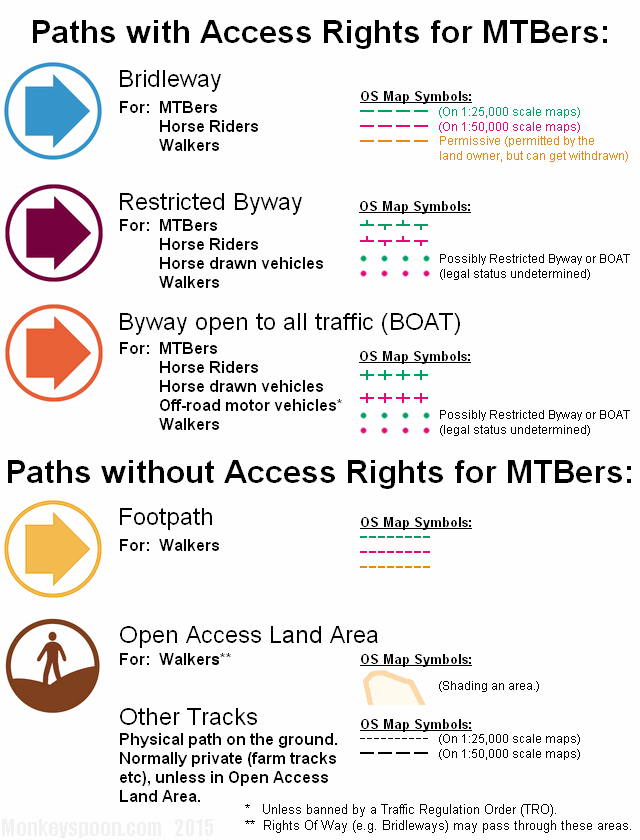
*About a year ago really.


News and information on tracks and trails and access for mountain bikers in the Peak District.
We recently* added the Mountain Biking in the Peak District Information page, that has some guidance on the type of paths mountain bikers can ride on in the Peak. It also covers maps and local bike shops.
*About a year ago really.
“Join our conversation and help create the new Peak District National Park Management Plan
A public consultation has been launched to get the views of anyone with an interest in how the Peak District National Park develops over the next five years and beyond.
The Join Our Conversation consultation asks for comments on a draft new National Park Management Plan. The plan will be the main policy document that guides what will happen in the national park between 2012 and 2017.”
http://www.peakdistrict.gov.uk/index/news/news-display-page.htm?id=24782
http://www.peakdistrict.gov.uk/npmpconsultation
The Peak District National Park Authority are consulting their new Management Plan document and are asking for people’s views via online an survey: https://www.surveymonkey.com/s/npmpbasic (This is also a longer survey, but it is probably only relevant if you read the whole document.) Part 2 gives an opportunity for general comment, which might be useful if you have a view on mountain biking you’d like them to hear. The consultation ends 1st of July (Friday).
![[]](https://monkeyspoon.com/Pictures/2011/11-05-18%20Chapel%20Gate/DSC02903.JPG "Click to enlarge")
The Chapel Gate track in Edale has been resurfaced and turned into a smooth motorway. The long and very rocky track was previously considered by many, us included, to be one of the most technically challenging (legal) tracks in the area. This is a sad day for mountain biking in the Peak District.
![[]](https://monkeyspoon.com/Pictures/2011/11-05-18%20Chapel%20Gate/DSC02904.JPG "Click to enlarge")
Last Tuesday we went up and took some pictures of the new state of the track, although we only had time for pictures from the bottom of the main section.
![[Gallery Link]](https://monkeyspoon.com/Pictures/SitePics/PagePic_Image.jpg) 11-05-18 Chapel Gate Track, 11 pictures of the current and previous state of the track.
11-05-18 Chapel Gate Track, 11 pictures of the current and previous state of the track.
10-01-21 Chapel Gate JI+JK, 16 Pictures by Jeff & Irwin.
Whilst the smoothing out (or “sanitising” to some) of technically challenging tracks in the Peak District often results in out cry from mountain bikers in online forums and in discussions with fellow bikers out on the tracks, there are a few more complicated issues at play with this one.
Sources and further info:
Chapel Gate Experimental Traffic Order – Peak District National Park Authority
Sensitive routes – Peak District National Park Authority
Chapel Gate Route Management Plan [PDF] – Peak District National Park Authority
Vehicles in the Countryside: March 2011 [PDF] – Peak District National Park Authority
LAF Vehicle Sub-group Meeting 5/8/2010 [PDF] – Peak District National Park Authority
![[]](https://monkeyspoon.com/Pictures/2011/11-05-18%20Chapel%20Gate/DSCF4038.JPG "Click to enlarge") |
![[]](https://monkeyspoon.com/Pictures/2011/11-05-18%20Chapel%20Gate/DSC02920.JPG "Click to enlarge") |
Whilst it would be easy to agree with banning vehicles from Chapel Gate, and other places they can legally drive, based on the damage they cause and subsequently cost, it’s perhaps a short-sighted view. Assuming a ban would be followed, where would they go instead? Would this increase traffic and therefore erosion and cost of maintenance on other BOATs? Would they then become like Chapel Gate and get similar bans? Would this lead to more illegal use and damage in less sustainable areas or on bridleways mountain bikers value? Another valid question is; can the council (and therefore taxpayers) continue to pay a lot of money to maintain the enjoyment of a relatively small user group?
Hard problems don’t have simple solutions.
As mountain bikers who enjoy technically challenging rocky descents and don’t enjoy smoothed out sandy motorways suitable only for family leisure cycling, we a take a certain amount of pleasure in seeing such “improvements” returned to rocky mayhem by the elements, but will this take much longer if vehicles are banned?
There are many good examples of self-sustaining rocky technical tracks, Hope Cross DH and Gores being two (bridleways). One thing most tracks will benefit from, though, is targeted maintenance; stopping water flowing down the track or draining dips where it collects and becomes a mud bath. The only question that remains is who will do this targeted maintenance, where are the fabled trail fairies?
Mountain bikers want maintenance to be carried out in a way that’s sympathetic to their use and enjoyment of the trails – that’s only going to happen if mountain bikers are involved in doing it. No one is going to come and ask us how we’d like it done if we don’t get off our back sides (or saddles more likely) and do something ourselves.
![]() Ride the Peak is a group of mountain bikers, from a variety of riding types and backgrounds, who are interested in maintaining and enhancing mountain biking in the Peak District.
Ride the Peak is a group of mountain bikers, from a variety of riding types and backgrounds, who are interested in maintaining and enhancing mountain biking in the Peak District.
|
Irwin, Shane and myself (Jeff) are part of Ride the Peak’s track maintenance group, which has previously undertaken small maintenance jobs on bridleways, mainly involving improving drainage (eg Aston Bridleway, Derwent Edge & Hollins Cross to Greenlands). More recently the group took on a larger job, doing maintenance on the bridleway which runs from the lay-by on the north side of Mam Tor to a junction with the bridleway from Hollins Cross at Greenlands and the track from Greenlands to Edale. [Track Page | Map] The main aims of the job were:
Starting in late June the group spent about 8 evenings over 3 months working on the track through wind, rain, darkness and midges (what is it with Edale midges?!). We adopted the top-down management approach; starting below the second gate, near the top of the track, filing in narrow ruts and making drainage channels into the ditch at the side. We then moved onto the straight with the high wall, this was a case of bringing most of the higher line down to fill in the gullied bottom line. Where drainage rollers were put in, small sections of the high line were left to aid drainage, it was later noticed they look remarkably like mini ‘bus stops’. 😯 In the next section we added some flowing, slightly bermed, curves while filling in the gullies. Lower down is a sort of left dip down a small rock step followed by a right shwosh up, pump, avoid a few rocks and out …well it makes more sense when you ride it. Another interesting feature is where we put in a 45° sloped wooden boarding to help hold back the earth for a slope down into some flowing curves before the wide gulley by the hawthorn tree. We used the two parallel straight lines that had developed to make one line with curves and we widened the narrow exit of the gulley and cut back overhanging gorse bushes.
For this section we had some aggregate surface material to use, which is better draining and longer lasting than normal soil, the only problem was that the aggregate was up the top of the hill by the second gate. We had two wheel barrows and a motorised wheel barrow to move it with, you might think pushing empty barrows up hill and full ones down hill would easy – WRONG! It was a constant battle to stop the barrow running away from you down the hill or gaining too much speed and spilling the precious load. Shane loved driving the petrol driven motorised barrow, which was cross between a wheel barrow and a military tank (I’m sure I heard him whispering to it at one point). It was decided that no work was needed lower down, so we didn’t do anything to the track below the wide gulley next to the hawthorn tree. The Peak Park also did work around the same time on the bridleway that runs from the top of track, around Mam Tor, towards Hollins Cross. Martyn Sharp, who is the Pennine Way ranger for the Peak Park and, as a MTBer, is a member of Ride the Peak, organised and oversaw the work of the Ride the Peak maintenance group, as well as making our digging legitimate (not just anyone can dig up bridleways).
At the end of January, Martyn, Irwin and I went back to see how the track had faired over the 4 months since we finished working on it. It was generally working well, with only a few area that might need looking at in the near future. The ground was frozen solid, so apart from axing out a few tyre ruts there wasn’t much work we could do, other than move a few stones to the side where part of the wall had come down. Fortunately we had brought out bikes and there was time for a short ride down the track, up to Hollins Cross then back up the ridge to the lay-by. Irwin had borrowed a nice HD helmet camera and there was still some snow and plenty of ice about, so there’s footage of Martyn coming off once and me twice. |
[Not a valid template] |
Below is a video and pictures of Shane & Jeff riding the Mam Tor to Greenlands bridleway, in October 09, a few weeks after the work was completed (Shane only had a rear brake):
09-10-10 MamTor-Greenlands ST+JK, 8 Pictures by Jeff & Shane
Helmet Camera run during the snow, gives a good idea of the track lengh and features.
As some of you may be aware myself, Jeff and Shane are members of Ride the Peak. ‘What is Ride the Peak?’ I hear you say.
“Ride the Peak is a group open to all with like-minded interests in maintaining and enhancing mountain biking in the Peak District”
A couple of weeks ago now we went to carry out some basic maintenance to the Derwent Edge bridleway. There was only a small group of the four of us. With Martin Sharp, who works for the Peak Park, keeping us in line we were able to achieve what we set out to do. Which was to unblock the ‘bomb holes’ so that they could start to dry out.

Anyone who has ever ridden there before will know that in the winter it get extremely muddy. Which leads to users (not just cyclists) trying to find alternative routes around the worst bits. But even in the summer some of the deeper bomb holes just don’t dry out. So we were trying to drain some of the largest puddles/pools of water. Although we did leave a couple as there were full of tadpoles. 🙂
 09-04-21 Derwent Edge Maintenance, 5 Pictures by Jeff


![[10'02'07 BWM JI+ST Spades 0928]](https://monkeyspoon.com/Pictures/SitePics/10'02'07 BWM JI+ST Spades 0928.JPG)
![[10'02'07 BWM Group 0896]](https://monkeyspoon.com/Pictures/SitePics/10'02'07 BWM Group 0896.JPG "The group were not impressed by Martyn's sliding thumb trick...")
![[10'02'07 BWM MS+JI Digging+Bikes 4262]](https://monkeyspoon.com/Pictures/SitePics/10'02'07 BWM MS+JI Digging+Bikes 4262.JPG)