Track: Hollins Cross – Castleton
Hollins Cross - Castleton is a bridleway near Edale, Castleton in the Peak District, UK. This page is intended to provide information for mountain biking on the track, although some descriptions and images may have become outdated (see image dates).
Rating: Technical / Speed / Fun: 

Height Descent / Distance: 140m / 1.29km
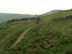
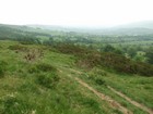
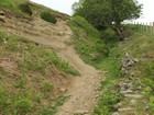
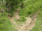
Surface: Grass and dirt on the top section with shale & gritstone rocks in places lower down.
Location: SK 138 844 - Bing OS Map (Desktop only) - Google Aerial Map
NOTE: The on the ground location of the current bridleway seems to vary from that shown by the OS map.
Starting on the ridge at Hollins Cross the bridleway initially follows the ridge before heading south east across the hill, it later switches back and comes to a junction with footpaths. Making a left turn into a gully before joining a lane to Castleton.
![[Video Link]](http://monkeyspoon.com/Pictures/SitePics/PagePic_Video.jpg) Video of riding Hollins Cross - Castleton in 2007, from 0:00 - 1:15.
Video of riding Hollins Cross - Castleton in 2007, from 0:00 - 1:15.


