


Tracks
![[heading_tracks]](https://monkeyspoon.com/Pictures/SitePics/PagePic_heading_tracks_948x170.jpg)
Welcome to the Monkeyspoon.com guide to mountain biking tracks & trails in Peaks District, in particular covering descents in North Derbyshire and the Hope Valley.
There’s nothing quite like mountain biking in the Peak District with it’s beautiful scenery and challenging and technical natural tracks. In the north of the Peak District is the Dark Peak which features gritstone and peat, gritstone providing good grip in the wet and dry, whereas the south, or White Peak, features limestone which is quite smooth and very slippery in the wet.
Below is a list of our pages about tracks in the Dark Peak area. They are all either Bridleways or BOATs (normally “Other Public Access Routes” on the OS map legend). For more information about tracks with access rights for MTBers or riding the Peak District, see our Mountain Biking in the Peak District Information page.
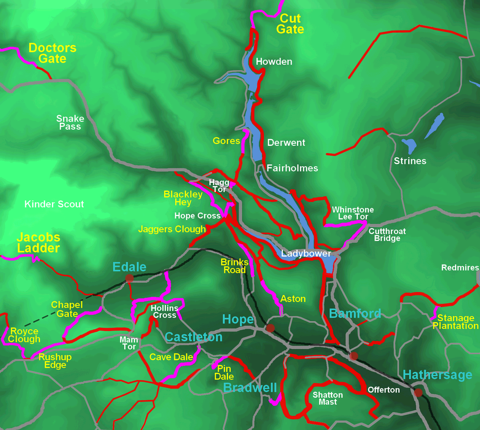
| Track | Ratings Technical | Speed | Fun | Height Descent | Length |
| Aston - Near: Hope |  | |  | |  | 110m | 1.78km |
| Blackley Hey - Near: Alport, Snake Pass (aka Potato Alley) | |  | | | 150m | 2.03km |
| Bradwell Edge - Near: Bradwell | | | | 100m | 0.75km |
| Brinks Road - Near: Hope (aka The Roman Road) | | | | 50m | 1.61km |
| Cave Dale - Near: Castleton |  | | | | | 220m | 2.3km |
| Chapel Gate - Near: Edale | | | | 200m | 2.22km |
| Cutthroat - Ladybower - Near: Ladybower | | | | 65m | 1.29km |
| Derwent Edge - Near: Ladybower, Derwent | | | | 160m | 2.33km |
| Doctor's Gate - Near: Glossop, A57 Snake Pass | | | | 290m | 4.34km |
| Gores - Near: Derwent, Fairholmes (aka Lockerbrook, Screaming Mile) | | | | 100m | 1.08km |
| Hagg Tor - Near: Ladybower & Derwent (aka Hagg Farm) | | | | 130m | 0.61km |
| Hollins Cross - BackTor Bridge - Near: Edale, Castleton | | | | 160m | 1.39km |
| Hollins Cross - Castleton - Near: Edale, Castleton | | | | 140m | 1.29km |
| Hollins Cross - Greenlands - Near: Edale, Castleton | | | | 80m | 1.05km |
| Hope Brink - Near: Hope & Aston | | | | 100m | 1.36km |
| Hope Cross - Near: Hope, Edale & Ladybower (aka The Beast of Hope Cross, The Beast) | | | | 100m | 1.2km |
| Jacob's Ladder - Near: Edale | | | | 170m | 1.1km |
| Mam Tor - Greenlands - Near: Edale, Castleton (aka Toboggan Run) | | | | 160m | 0.99km |
| Pin Dale - Near: Hope, Castleton & Bradwell (aka Black Rabbit) | | | | 100m | 0.8km |
| Roych Clough - Near: Chinley & Edale | | | | 90m | 0.75km |
| Rushup Edge - Near: Chinley & Edale | | | | 60m | 0.85km |
| Stanage Plantation - Near: Hathersage | | | | 130m | 0.9km |
| Whinstone - Cutthroat - Near: Ladybower & Derwent | | | | 100m | 1.7km |
Below are minor tracks, which are of less interest or with limited information to show.
| Track |
| Brough Lane - Near: Brough, Bradwell & Abney |
| Dirtlow Rake - Near: Hope |
| Hope Roman Road (Middle) - Near: Hope |
| Jaggers Clough - Near: Hope, Edale |
| Mam Tor - Near: Castleton, Edale |
| Offerton Moor - Near: Bamford, Hathersage |
| Stanage Causeway - Near: Bamford, Hathersage |
Lady Canning’s Plantation Trails
2 short purpose built MTB trails in a small pine copse located between Hathersage and Sheffield.Local Maps
It's strongly recommended that you carry a decent map when you're out riding in the Peak District. The Ordnance Survey Explorer maps have great detail and clearly show rights of way and elevation. There are two Explorer maps covering the Peak District; Dark Peak area (OL1), including the Hope Valley and north, and White Peak (OL24) area, covering south of the Hope Valley.
Local Bike Shops
There are two bike shops in the Hope Valley; Bike Garage in Bamford, which also offers mountain bike hire, and 18 Bikes in Hope.
For more information about the area and visiting see the websites list on our Links page.
Some statistics on legal riding in the Peak District
Bridleways account for only 12% of paths (footpaths & bridleways) in the Peak District, so for every 7.3 kilometres of footpath there is only 1 kilometre of bridleway.* 36%, 524 kilometres square, of the Peak District is open access land (normally only allowing access by foot).**
(Statistics calculated from a 2008 Peak Park document: *2001 **2005)
Please note: These pages are intended to be a guide to local tracks, they have been created to the best of our knowledge at the time of writing. You are responsible for yourself and so use any information given in these pages at your own risk.